Beverley Brook and the Thames Water Pipe Track
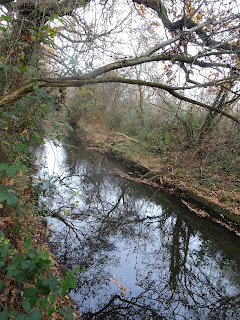
The Beverley Brook rises near Nonsuch Park at Stoneleigh and forms the eastern boundary to the borough from Motspur Park through New Malden to Roehampton Vale. Along the Kingston boundary it forms part of a number of sites from Back Green (Sutton) Manor Park, Malden Golf Course, Coombe Wood and Wimbledon Common. (ref side-tabs Beverley Brook). Today we set off on the west or sunny side of the riparian vegetation, fringing the sports fields owned by Kingston council.

Ramshorn gall
Here a wealth of galls were noted on oak: marble, ramshorn, cherry, currant and knopper galls which
is a bowl shaped protrusion. This is caused by a tiny gall wasp, Andricus quercuscalicis. It produces ridged outgrowths on the acorns of our native pedunculate oak; forming in August, becoming woody and brown. A second generation then develops in the catkins of Turkey Oak.

Hart's tongue and male fern
Along the banks of the brook - wherever the tree cover opens - are found both male and hart's tongue ferns. In the woodland - particularly around Fishpond's Wood - broad buckler fern is located. Norway maple was a surprising but colourful invader in the woodland.

Environment Agency gauging station
After leaving the woodlands of Merton, to continue along the brook, it is necessary to negotiate the A3 via a subway followed by weaving through a residential area and along Cambridge Avenue to New Malden. Here the brook can be picked up again near the Thames Water Pipe Track at Alric Avenue.

Arrow marks bridge over Alric Ave
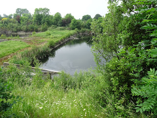
This Site of Nature Conservation Importance is about to undergo radical changes to accommodate a cycle route as part of the council's Go-Cycle scheme (see previous posts 21.3.15). The Kingston Handbook written by the London Ecology Unit (1992) includes the pipe track in with the Malden Golf Course (and Coombe Brook) as well as a section of the Beverley Brook, which curls like an 'S' shape in the south-east corner of the GC before crossing the pipe track and railway and into Beverley Park, heading south.
The handbook states that the Thames Water Pipe Track runs north of the railway lines - giving the appearance of a green lane- only it carries 5 water pipes from Seething Wells. It describes lush grassland, enlivened with flowers such as: ladies smock; meadow vetchling; birds foot trefoil; and meadow vetchling. Halfway along the track where the pipes leak have arisen wetlands, where yellow flag iris, soft and hard rushes and phragmites reed provide habitat for dragonflies and amphibians.

Pipe Track seen from Alric Avenue
Fast forward to 2016 when Thames Water undertook major repairs to the pipework under the trackway. Leaking pipework was removed leaving a deck of sleepers, which will be the canvas upon which the Council scheme - in partnership with the Sustrans - will be revealed in the current planning application 17/15227 or Pipe Track to construct a 1.2 km cycling and walking path along the railway line. This will include installation of a 2m-3m impenetrable fence and associated lighting, and landscaping.
Whilst there is sympathy with the lack of appropriate surveys due to the difficulties in site access- the fauna and flora are widely known due the badgers, deer and foxes, reptiles and amphibians that appear in residents gardens - the Sustrans promise at the consultation stage ( see post 25.3.15) that 'this would be designed as a wildlife haven' will not materialise in this application as it is being designed solely for the use of people. Fencing to exclude the communication of animals between gardens and lighting to exclude nocturnal wildlife including the brown long-eared bat recorded in the Graves 2015 survey.
The council could be in breach of the Natural Environment and Rural Communities Act 2006, which requires it to identify those Section 40 species and conserve biodiversity in this scheme. Instead the Site of Nature Conservation Importance will be lost as it is urbanised with 3m high fences and lighting as well as non-native species of prickly plants.
This is not habitat improvement and when a certain level of urbanisation is reached, so can the 'tipping point' for many animals and birds. For even the commonest bat species this is now determined as being 60% of built surface area and includes the anthropogenic effect of lighting.
The handbook states that the Thames Water Pipe Track runs north of the railway lines - giving the appearance of a green lane- only it carries 5 water pipes from Seething Wells. It describes lush grassland, enlivened with flowers such as: ladies smock; meadow vetchling; birds foot trefoil; and meadow vetchling. Halfway along the track where the pipes leak have arisen wetlands, where yellow flag iris, soft and hard rushes and phragmites reed provide habitat for dragonflies and amphibians.
Pipe Track seen from Alric Avenue
Whilst there is sympathy with the lack of appropriate surveys due to the difficulties in site access- the fauna and flora are widely known due the badgers, deer and foxes, reptiles and amphibians that appear in residents gardens - the Sustrans promise at the consultation stage ( see post 25.3.15) that 'this would be designed as a wildlife haven' will not materialise in this application as it is being designed solely for the use of people. Fencing to exclude the communication of animals between gardens and lighting to exclude nocturnal wildlife including the brown long-eared bat recorded in the Graves 2015 survey.
The council could be in breach of the Natural Environment and Rural Communities Act 2006, which requires it to identify those Section 40 species and conserve biodiversity in this scheme. Instead the Site of Nature Conservation Importance will be lost as it is urbanised with 3m high fences and lighting as well as non-native species of prickly plants.
This is not habitat improvement and when a certain level of urbanisation is reached, so can the 'tipping point' for many animals and birds. For even the commonest bat species this is now determined as being 60% of built surface area and includes the anthropogenic effect of lighting.
Comments
Post a Comment
Please share your thoughts